Next sale 16th of June.
Our next sale is the 16th of June at 9:45AM with 649 lots up for auction. To get a taste of what we sell see our previous catalogues or view our upcoming auctions.
The pictures below are updated regularly and are subject to change.
It is advised to request a condition report as items are sold as seen with faults (if any) and errors in description (if any) otherwise refunds will not be issued without written condition report
Want to be notified of future sales click here
How to bid
You can leave an maximum bid with us which allows us to bid on your behalf upto a specified amount
You can leave an e-absentee bid by registering for an account through the indvidual lot pages
Or you can bid live online through the following links:
Register through Easy Live Auctions 27.6% (incl VAT) or £3 one off fee and 24% (incl VAT) buyer premium
Register through the-saleroom.com 30% (incl VAT) buyer premium
Jump to lot
⠛View as grid ≡View as list Page: Per page:
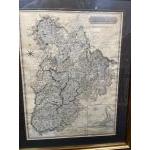
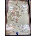
Lot 167
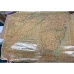
LOCAL INTEREST - FRAMED ANTIQUE map of PEEBLES-SHIRE 1821 published by John Thompson & Co Edinburgh 1821
Drawn by Wm Johnson Land Surveyors and engraved by WD Assuville of Edinburgh to also include The Town Of Peebles bottom right of map inset - map dimensions 53cm x 70cm and frame size 72cm x 90cm approx
Guide: £150-450
Click here to view more info and more photos
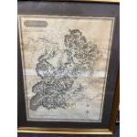
Lot 168
FRAMED ANTIQUE map of SELKIRK-SHIRE 1824 published by John Thompson & Co Edinburgh
Drawn by Wm Johnson Land Surveyors and attended by The Right Honourable Lord Napier - map dimensions 53cm x 70cm and frame size 72cm x 90cm approx
Guide: £110-200
Click here to view more info and more photos
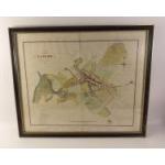
Lot 169
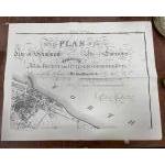
A very attractive and interesting original hand coloured Plan of Lanark dated 1825. From Actual Survey by John Wood Edinburgh and published by P Brown & T Nelson, Edinburgh. Modern frame, heavy centre fold. Beautiful colouration and superb detail. Measures 62 x 52cm approx.
Guide: £20-60
Click here to view more info and more photos
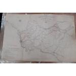
Lot 170
A hessian map dated 1852 of TURNPIKE & PARISH ROADS of AYR by James McDerment & Sons. Heavy centre fold, unframed. Colours still bright, a rare and interesting map. Measures 96 x 62cm approx.
Guide: £20-60
Click here to view more info and more photos
Lot 171
An interesting pressed educational Oxford Relief Map Series 4, Map 4 Glasgow Edinburgh Central Belt in box with two others. Measures 47 x 35cm approx. Dusty from long term storage but undamaged.
Guide: £10-20
Click here to view more info and more photos
Lot 172
SHETLAND ISLANDS BY JOHNSTONES. A vintage educational rolled wall map in complete order with bright colours. Measures 107 x 66 cm approx.
Guide: £15-35
Click here to view more info and more photos
Lot 173
VINTAGE c1950's/60's COLOURFUL ORDNANCE SURVEY showing PEEBLES AND GALASHIELS and another showing EDINBURGH land utilisation survey maps - the Edinburgh map is on canvas style dimensions on larger Edin map 34"x 30" and the slightly smaller Peebles & Galashiels dimensions 26" wide x 33" width approx
Guide: £15-45
Click here to view more info and more photos
Lot 174
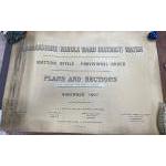
LANARKSHIRE (Middle Ward District) Water plans and sections Nov 1907 -session 1908 sheet No 5 County Of Lanark (so far as relating to the Parish of Blantyre) - large rolled-up plans really interesting reading! - dimensions 40" wide x 26.5" height approx
Guide: £10-45
Click here to view more info and more photos
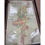
Lot 175
ORKNEY ISLANDS BY JOHNSTONES. A vintage educational rolled wall map in complete order with bright colours. Measures 107 x 66 cm approx.
Guide: £15-45
Click here to view more info and more photos
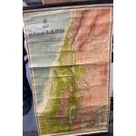
Lot 176
VINTAGE EDUCATIONAL - The HOLY LAND to illustrate The New Testament constructed and engraved by W & AK Johnston Ltd Edinburgh - a fine example! - dimensions 25" wide x 42"
Guide: £20-55
Click here to view more info and more photos
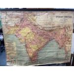
Lot 177
FASCINATING AND COLOURFUL c1950's VINTAGE EDUCATIONAL PHILIP'S smaller school room wall map of THE INDIAN EMPIRE scale 1:4,000,000 - dimensions 43" wide x 34" height approx - the map requires a small repair to affix it back to the wooden pole (an easy repair!)
Guide: £15-65
Click here to view more info and more photos
Lot 178
VINTAGE EDUCATIONAL -THE BRITISH ISLES coloured wall chart c1960's classroom wall map by Johnston Ltd Edinburgh & London - dimensions 35" height x 27"
Guide: £15-45
Click here to view more info and more photos
Lot 179
VINTAGE EDUCATIONAL Johnston (Geographers Engravers and Printers) wall map of SHETLAND ISLANDS HJALTLAND 42" height x 26"wide
Guide: £15-55
Click here to view more info and more photos
Lot 180
VINTAGE COLOURFUL c1950's/60's ORDNANCE SURVEY sheet 79 Land Utilisation map of LANARK - dimensions 33" x 26" approx
and also an OS Land Utilisation map of Falkirk and Motherwell c1950's/1960's sheet 73 - dimensions 39" x 30" approx
Guide: £20-60
Click here to view more info and more photos
Lot 181
FASCINATING! VINTAGE ORDNANCE SURVEY MAPS 1944 in colour depicting Types Of Farming in Scotland, Ireland and Wales 34" x 43"
and
also OS wall map depicting Land Classification 1945 34" x 43"
and also
an OS Vegetation Map - all maps dimensions are the same 34" x 43"
Guide: £25-70
Click here to view more info and more photos
Lot 182
ANTIQUE PAISLEY PARISH LARGE WALL MAP - ORDNANCE SURVEY MAP ' SEWING' THE PARISHES OF PAISLEY 1874 hessian backed wall map - the top wooden hanger is precariously attached and can be easily reattached/repaired - otherwise it is in good condition for its age - dimensions 42" wide x 50" height approx
Guide: £20-80
Click here to view more info and more photos
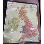
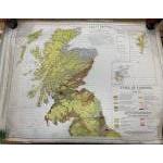
Lot 183
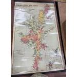
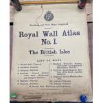
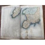
ROYAL WALL ATLAS No 1 - Teaching and Test maps Combined
publisher T NELSON & SONS of EDINBURGH
The British Isles combined set of wall maps to include
1 British Isles - Physical
2 Scotland - Physical
3 Scotland - Political
4 Scotland Central Section with inset Central Section Edinburgh and Glasgow District
5 England - Physical
6 England - Political
7 England - Northern Section with inset Liverpool and Manchester District
8 England - South-Eastern Section with inset London District
9 England - South - Western Section
10 Ireland - Physical
11 Ireland - Political
12 British Isles - Railways and Industries - framed pages would look AWESOME framed singly!
Dimensions 32" wide x 40" height approx
Condition: the bottom edge of each map is slightly torn and frayed
Guide: £25-100
Click here to view more info and more photos
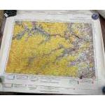
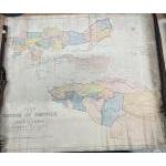
Lot 184
ORDNANCE SURVEY SCOTLAND Part series printed from an Electrotype taken in 1885 hessian backed to contain colour detail scenes of
sheet 19 Bowmore (Islay)
sheet 20 Killean
sheet 27 Portaskaig
sheet 28 Jura
sheet 35 Colonsay
sheet 36 Kilmartin
Dimensions of each sheet 27" width x 21" height
Guide: £20-100
Click here to view more info and more photos
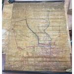
Lot 185
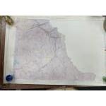
INTERESTING AND RARE! Revised and Reduced from Ordnance Survey 1866 FENWICK (Ayrshire) THE ESTATE OF FENWICK in the Parish of Ayr - in a tight rolled-up state and hessian backed - dimensions 39" wide x 46" height approx
Guide: £35-85
Click here to view more info and more photos
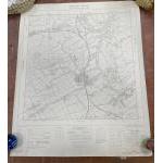
Lot 186
VINTAGE ORDNANCE SURVEY map of Edinburgh showing Turnhouse Airport sheet, NT 17 SE
with also OS map showing Berwickshire Lauder Burgh sheet NT 54 NW with also OS Selkirkshire sheet NT 22 SW - in good condition overall with no obvious tears etc -dimensions approx 22" x 27" approx
Guide: £10-45
Click here to view more info and more photos
Lot 187
NICE CRISP CONDITION! KIRKWOOD PLAN OF EDINBURGH 1817 reprinted version by Caledonian Books 1997 sheets 12 4 5 and 6 dimensions 32" wide x 25" height - lovely condition with only two folds
Guide: £15-50
Click here to view more info and more photos
Lot 188
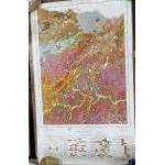
FROM THE GEOLOGICAL SURVEY OF SCOTLAND map of DUMFRIESSHIRE sheet XLL surveyed in 1856 by Captain Stotherd RE - Geological map dimensions each 39" x 27.5" approx with a second survey map showing south of Scotland (Crawfordjohn) sheet XLLX - both in good condition
Guide: £15-65
Click here to view more info and more photos
Lot 189
ORDNANCE SURVEY OF GREAT BRITAIN SOIL SURVEY OF SCOTLAND SYSTEMIC SOIL SURVEY Peebles Sheet 24 and part of Edinburgh sheet 32(SOIL) 46" x 28" approx
and also a second survey map
SOIL SURVEY OF SCOTLAND - LAND USE CAPABILITY PEEBLES SHEET 24 and part of EDINBURGH sheet 32 (Land Of Capability) dimensions 27.5" wide x 41" height approx
Guide: £25-75
Click here to view more info and more photos
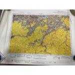
Lot 190
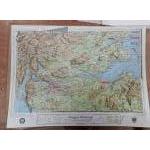
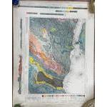
Stamped July1930 - TWO COLOURFUL ORDNANCE SURVEY OF SCOTLAND EDINBURGH AND PEEBLESSHIRE maps sheet(s) 32 GEOLOGICAL SURVEY OF SCOTLAND detailed maps - dimensions each 26" height x 36" wide approx showing sections of West Lothian Shale Field - EXTREMELY INTERESTING!
Guide: £25-65
Click here to view more info and more photos
Lot 191
Large wall map of BACON'S c1930's New Survey Map of The Counties of
INVERNESS, NAIRN, ELGIN, BANFF, ABERDEENSHIRE, KINCARDINE, FORFAR, PERTH & KINROSS, hessian backed x dimensions - 49"W x 30"H
Guide: £15-35
Click here to view more info and more photos
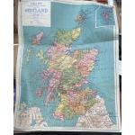
Lot 192
VINTAGE PHILIPS colourful sectional small school-room map of Scotland hessian backed - dimensions - 93cm wide x 125cm height approx
Guide: £10-25
Click here to view more info and more photos
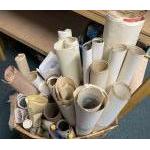
Lot 193
LUCKY DIP! A large box with a HUGE assortment of old (some c1930's) ordnance survey maps, mainly Edinburgh, Scotland and UK, Ordnance Survey and much more!
Guide: £25-100
Click here to view more info and more photos
Lot 194
A great opportunity for RAILWAY TRACK/TRAIN ENTHUSIASTS! A lot of 8 railway track maps from areas such as Bushbury (approx. 47cm x 77cm), Wolverhampton (approx. 52cm x 77cm), Hampton in Arden (approx. 40cm x 77cm), Water Orton East (approx. 49cm x 75cm), Water Orton West (approx. 49cm x 74cm), Birmingham New Street (approx. 46cm x 93cm), Whitacre (approx. 52cm x 77cm) and Walsall District (approx. 77cm x 131cm)..
Guide: £35-90
Click here to view more info and more photos
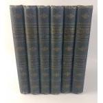
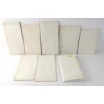
Lot 195
Six volumes of the Ordnance GAZETTEER of SCOTLAND in blue bindings. Published by William McKenzie. In good order complete with plates and fold out maps.
Guide: £30-60
Click here to view more info and more photos
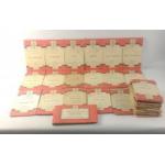
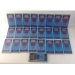
Lot 196
A fantastic lot for LOVERS of MAPS, HIKING and CYCLING! A substantial collection of 29 One-Inch Tourist Map ordnance survey maps to include Scottish areas such as Loch Tay, Ben Nevis/Glen Coe, St. Andrews and Kirkcaldy published by National Grid Seventh Series published in the 1950s and 60s.
Guide: £15-30
Click here to view more info and more photos
Lot 197
A mixed lot of ORDNANCE SURVEY MAPS to include map printers such as Ordnance Survey Office, Southhampton, Caledonian Books, National Grid and Bartholomew's (maps dissected and mounted on cloth), and covering areas such as Guildford, Falkirk, & Lanark, Lake District, England and Wales.
Guide: £14-30
Click here to view more info and more photos
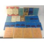
Lot 198
A great lot for afficionados of cloth-mounted maps! A selection of BARTHOLOMEW'S REVISED HALF-INCH CONTOURED MAPS of SCOTLAND to include areas such as Galloway, Perthshire, The Solway, Ayrshire and Tweeddale among many others.
Guide: £30-60
Click here to view more info and more photos
Lot 199
A mixed lot of ORDNANCE SURVEY MAPS to include map publishers such as Bartholomew's and Ordnance Survey Southhampton covering areas such as Scotland - Lochgilphead & surrounding area, Raasay, Applecross & Loch Torridon and Oban, along with areas in England to include Ripon and Wensleydale, Blackburn & Burnsley, South West England and Wales.
Guide: £15-30
Click here to view more info and more photos

Lot 380
A box of old foldaway maps including tourist maps of the Lake District plus many Scottish maps and several editions of the Countryman
Guide: £15-35
Click here to view more info and more photos