This TIMED sale ends on the 26th of June with lots starting close at 18:00PM and has 137 lots up for auction. To get a taste of what we sell see our previous catalogues or view our upcoming auctions.
The pictures below are updated regularly and are subject to change.
It is advised to view the items before hand or request a condition report as items are sold as seen with faults (if any) and errors in description (if any) otherwise refunds will not be issued without written condition report
Want to be notified of future sales click here
How it works
You will need to click on the link below to take your to the online platform that the timed auction is taking place on.
Once there you will need to register for the auction (green button on Easy Live Auction). Once your registered then your ready to bid. Just place the maxiumum hammer price you wish to leave and Easy Live Auction will bid on your behalf. Each lot starts off at the starting price and whomever has the highest bid when the lot closes wins the lot on 26th of June.
If you place a bid within the last 30 minutes, the time will be extended by 10 minutes to allow the under bidder a chance to bid again.
Have a read of how Easy Live Auction describe them (link)
You can bid on the lots through the following links:
Register through Easy Live Auction 3% (plus VAT) surcharge
Jump to lot
⠛View as grid ≡View as list Page: Per page:
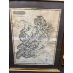
Lot 168
FRAMED ANTIQUE map of SELKIRK-SHIRE 1824 published by John Thompson & Co Edinburgh
Drawn by Wm Johnson Land Surveyors and attended by The Right Honourable Lord Napier - map dimensions 53cm x 70cm and frame size 72cm x 90cm approx
Guide: £90-200
Click here to view more info and more photos
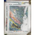
Lot 190
Stamped July1930 - TWO COLOURFUL ORDNANCE SURVEY OF SCOTLAND EDINBURGH AND PEEBLESSHIRE maps sheet(s) 32 GEOLOGICAL SURVEY OF SCOTLAND detailed maps - dimensions each 26" height x 36" wide approx showing sections of West Lothian Shale Field - EXTREMELY INTERESTING!
Guide: £20-65
Click here to view more info and more photos
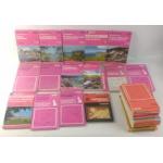
Lot 199
A mixed lot of ORDNANCE SURVEY MAPS to include map publishers such as Bartholomew's and Ordnance Survey Southhampton covering areas such as Scotland - Lochgilphead & surrounding area, Raasay, Applecross & Loch Torridon and Oban, along with areas in England to include Ripon and Wensleydale, Blackburn & Burnsley, South West England and Wales.
Guide: £10-30
Click here to view more info and more photos
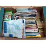
Lot 380
A box of old foldaway maps including tourist maps of the Lake District plus many Scottish maps and several editions of the Countryman
Guide: £10-35
Click here to view more info and more photos